
Share this:


Remote Sensing, Vol. 15, Pages 2250: Integrating GIS, Remote Sensing, and Citizen Science to Map Oak Decline Risk across the Daniel Boone National Forest
Remote Sensing doi: 10.3390/rs15092250
Authors:
Ellen Crocker
Kumari Gurung
Jared Calvert
Charles Dana Nelson
Jian Yang
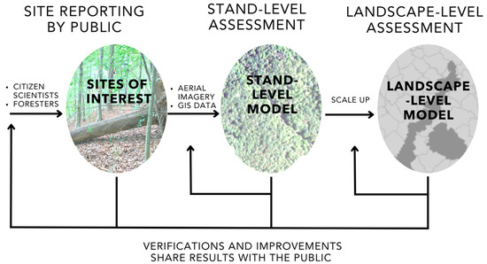
Oak decline is a general term used for the progressive dieback and eventual mortality of oak trees due to many compounding stressors, typically a combination of predisposing, inciting, and contributing factors. While pinpointing individual causes of decline in oak trees is a challenge, past studies have identified site and stand characteristics associated with oak decline. In this study, we developed a risk map of oak decline for the Daniel Boone National Forest (DBNF), combining GIS, remote sensing (RS), and public reporting (citizen science, CS). Starting with ground reports of decline (CS), we developed a site-scale model (GIS and RS) for oak decline based on four previously identified predisposing factors: elevation, slope, solar radiation, and topographic wetness. We found that areas identified in the model as having a high oak decline risk also reflected areas of observed oak decline (CS). We then optimized and expanded this risk model to the entire range of the DBNF, based on both site characteristics (as piloted for the case study site) and stand inventory data. The stand inventory data (including species composition and age) further improved the model, resulting in a risk map at the landscape level. This case study can serve as a planning tool and highlights the potential usefulness of integrating GIS, remote sensing, and citizen science.


More Stories
Will County, Illinois 1864 Map – May 20, 2023 at 04:14AM
This kid on Google Map trying to get by – April 27, 2023 at 05:05PM
World of Hyatt: Complete list of all-inclusive properties in Europe (with map) – April 27, 2023 at 04:57PM