
Share this:


Remote Sensing, Vol. 13, Pages 4775: Prediction of Erosion-Prone Areas in the Catchments of Big Lowland Rivers: Implementation of Maximum Entropy Modelling—Using the Example of the Lower Vistula River (Poland)
Remote Sensing doi: 10.3390/rs13234775
Authors:
Marta Brzezińska
Dawid Szatten
Zygmunt Babiński
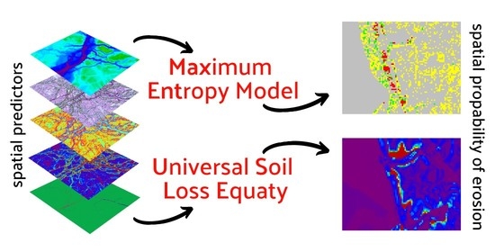
It is common knowledge that erosion depends on environmental factors modified by human activity. Erosion within a catchment area can be defined by local lithological, morphometric, hydrological features, etc., and land cover, with spatial distribution described by means of remote sensing tools. The study relied on spatial data for the catchment of the Lower Vistula—the biggest river in Poland. GIS (SAGA, QGIS) tools were used to designate the spatial distribution of independent environmental variables that determined the process of erosion according to land cover types within the Lower Vistula catchment (Corine Land Cover). In addition, soil loss in the catchment area was calculated using the USLE model (Universal Soil Loss Equation). The spatial data was used to determine the predictive power of variables for the process of erosion by applying the maximum entropy model (MaxEnt) commonly used in fields of science unrelated to fluvial hydrology. The results of the study pointed directly to environmental features strongly connected with the process of erosion, identifying areas susceptible to intensified erosion, and in addition positively verified by USLE. This testifies to the correct selection of the proposed method, which is a strong point of the presented study. The proposed interdisciplinary approach to predict erosion within the catchment area (MaxEnt), widely supported by GIS tools, will allow the identification of environmental pressures to support the decision-making process in erosion-prone areas.
 This information was first published on https://www.mdpi.com/2072-4292/13/23/4775


More Stories
Facebook Fact-Checker CENSORS Heritage Video Quoting Biden’s Own Words on Gas Policy – March 19, 2022 at 06:49PM
General Mills (GIS) Gains But Lags Market: What You Should Know
CAD Designer